RAMMS::Avalanche
An accurate prediction of avalanche runout distances, flow velocities and impact pressures in natural three-dimensional terrain is the driving motivation behind the development of improved snow avalanche dynamics models. These numerical models are typically applied in avalanche hazard mapping studies, both to back-calculate documented avalanche events at a particular site as well as to forward calculate the consequences of possible hazard scenarios. The quality of the results depends highly on the experience and know-how of the avalanche expert, especially when defining the initial conditions of the hazard scenario, but also on the ability of the numerical model to accurately simulate flowing snow in natural three-dimensional terrain. The computer model must allow the expert to easily and realistically define terrain, release conditions, track roughness and vegetation; the model output must be easily visualized and interpreted so that the expert can confirm or discard simulation results.
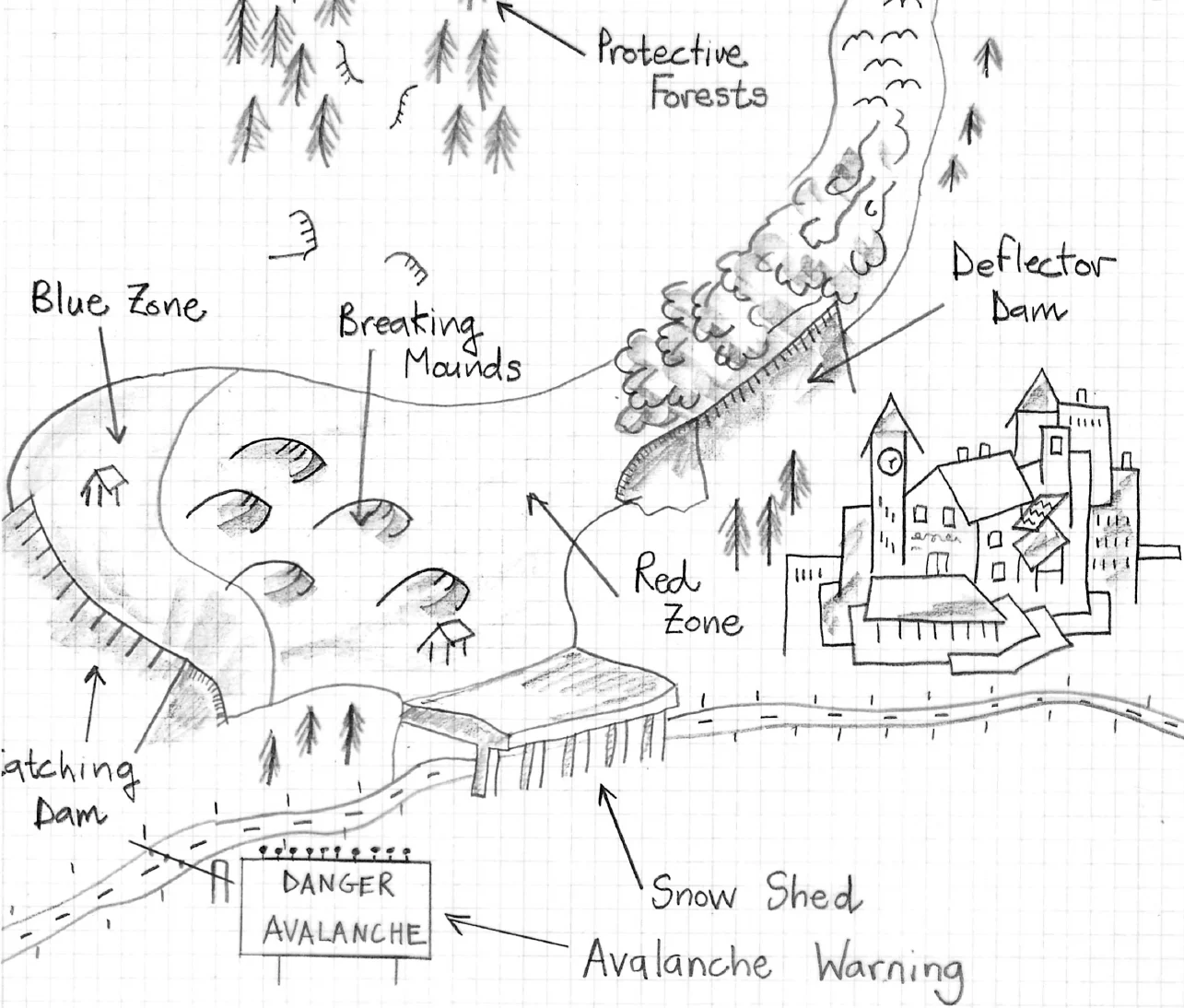
Because RAMMS is used for hazard mapping in Switzerland, it must be used with regard to existing calculation guidelines in Switzerland (Salm et al., 1990). For this reason, the Voellmy-Salm (VS) model (Salm, 1993), which is used in the Swiss Guidelines for avalanche runout calculation as well as in the one-dimensional AVAL-1D code is implemented in RAMMS. In practical applications, the VS model has proven to be simple (it contains only two flow parameters) and numerically accurate.
Theory
The RAMMS::AVALANCHE module combines state-of-the-art numerical solution methods with helpful input features and user-friendly visualization tools. Many of the input and output features have been optimized to allow engineers in practice to easily modify hazard scenarios and control simulation results.
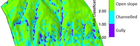
Avalanche flow heights and velocities are calculated on three-dimensional digital terrain models. Single or multiple release areas are easily specified using GIS type drawing features. Users are provided with useful overview information of simulations, including all-important information of the release area (mean slope, total volume), flow behaviour (max flow velocities and heights) and stopping behaviour (mass flux). Maps and remote sensing imagery can be superimposed on the terrain models to aid the specification of input conditions and calibrate the model with known events.
Downloads
RAMMS::Avalanche
Publications
Key AVALANCHE Publications
Bühler, Y.; Von Rickenbach, D.; Christen, M.; Margreth, S.; Stoffel, L.; Stoffel, A.; Kühne, R., 2018: Linking modelled potential release areas with avalanche dynamic simulations: an automated approach for efficient avalanche hazard indication mapping. In: 2018: International snow science workshop proceedings 2018. International snow science workshop, ISSW 2018, Innsbruck. 810-814.
Christen, M.; Kowalski, J.; Bartelt, P., 2010: RAMMS: numerical simulation of dense snow avalanches in three-dimensional terrain. Cold Regions Science and Technology, 63, 1-2: 1-14. doi: 10.1016/j.coldregions.2010.04.005
Christen, M.; Bartelt, P.; Kowalski, J., 2010: Back calculation of the In den Arelen avalanche with RAMMS: interpretation of model results. Annals of Glaciology, 51, 54: 161-168. doi: 10.3189/172756410791386553
Gruber, U.; Bartelt, P., 2007: Snow avalanche hazard modelling of large areas using shallow water numerical methods and GIS. Environmental Modelling and Software, 22, 10: 1472-1481. doi: 10.1016/j.envsoft.2007.01.001
AVALANCHE Publication list
Frigo, B.; Bartelt, P.; Chiaia, B.; Chiambretti, I.; Maggioni, M., 2021: A reverse dynamical investigation of the catastrophic wood-snow avalanche of 18 January 2017 at Rigopiano, Gran Sasso National Park, Italy. International Journal of Disaster Risk Science, 12: 40-55. doi: 10.1007/s13753-020-00306-6
Bebi, P.; Bast, A.; Helzel, K.; Schmucki, G.; Brozova, N.; Bühler, Y., 2021: Avalanche protection forest: from process knowledge to interactive maps. In: Beguš, J.; Berger, F. (eds), 2021: Protective forests as Ecosystem-based solution for Disaster Risk Reduction. London, IntechOpen Limited. (11 pp.). doi: 10.5772/intechopen.99514
Braun, T.; Frigo, B.; Chiaia, B.; Bartelt, P.; Famiani, D.; Wassermann, J., 2020: Seismic signature of the deadly snow avalanche of January 18, 2017, at Rigopiano (Italy). Scientific Reports, 10, 1: 18563 (10 pp.). doi: 10.1038/s41598-020-75368-z
Bartelt, P.; Buser, O.; Christen, M.; Caviezel, A., 2019: Dynamic magnification factors for snow avalanche impact (with pile-up) on walls and pylons. In: Papadrakakis, M.; Fragiadakis, M. (eds), 2019: COMPDYN 2019. 7th international conference on computational methods in structural dynamics and earthquake engineering. Proceedings. COMPDYN 2019. 7th ECCOMAS thematic conference on computational methods in structural dynamics and earthquake engineering, Crete, Greece. 4376-4385.
Bebi, P.; Bartelt, P.; Rixen, C., 2019: Lawinen und andere Schneebewegungen. In: Wohlgemuth, T.; Jentsch, A.; Seidl, R. (eds), 2019: Störungsökologie. Bern, Haupt Verlag. 175-187.
Bühler, Y.; Von Rickenbach, D.; Christen, M.; Margreth, S.; Stoffel, L.; Stoffel, A.; Kühne, R., 2018: Linking modelled potential release areas with avalanche dynamic simulations: an automated approach for efficient avalanche hazard indication mapping. In: 2018: International snow science workshop proceedings 2018. International snow science workshop, ISSW 2018, Innsbruck. 810-814.
Monti, F.; Alberti, R.; Comin, P.; Wolynski, A.; Vallata, L.; Bühler, Y., 2018: Automated identification of forest with protective function against snow avalanches in the Trento province (Italy). In: 2018: International snow science workshop proceedings 2018. International snow science workshop, ISSW 2018, Innsbruck. 731-735.
Maggioni, M.; Bovet, E.; Freppaz, M.; Segor, V.; Bühler, Y., 2018: Potential of automated avalanche dynamic simulations for large scale hazard indication mapping in Italy: a first test application in Aosta Valley. In: 2018: International snow science workshop proceedings 2018. International snow science workshop, ISSW 2018, Innsbruck. 736-739.
Semakova, E.; Safronov, V.; Mamaraimow, A.; Nurtaev, B.; Semakov, D.; Bühler, Y., 2018: Applying numerical snow avalanche simulations for hazard assessment in the Kamchik pass area, Uzbekistan. In: 2018: International snow science workshop proceedings 2018. International snow science workshop, ISSW 2018, Innsbruck. 701-704.
Bühler, Y.; Von Rickenbach, D.; Stoffel, A.; Margreth, S.; Stoffel, L.; Christen, M., 2018: Automated snow avalanche release area delineation – validation of existing algorithms and proposition of a new object-based approach for large-scale hazard indication mapping. Natural Hazards and Earth System Science, 18, 12: 3235-3251. doi: 10.5194/nhess-18-3235-2018
Bartelt, P.; Vera Valero, C.; Feistl, T.; Christen, M.; Bühler, Y.; Buser, O., 2015: Modelling cohesion in snow avalanche flow. Journal of Glaciology, 61, 229: 837-850. doi: 10.3189/2015JoG14J126
Aydin, A.; Bühler, Y.; Christen, M.; Gürer, I., 2014: Avalanche situation in Turkey and back calculation of selected events. Natural Hazards and Earth System Science, 14, 5: 1145-1154. doi: 10.5194/nhess-14-1145-2014
Bartelt, P.; Buser, O.; Bühler, Y.; Dreier, L.; Christen, M., 2014: Numerical simulation of snow avalanches: modelling dilatative processes with cohesion in rapid granular shear flows. In: Hicks, M.A.; Brinkgreve, R.B.J.B.; Rohe, A. (eds), 2014: Numerical Methods in Geotechnical Engineering – Proceedings. 8th European conference on numerical methods in geotechnical engineering (NUMGE 2014), Delft, The Netherlands. 327-332.
Bugnion, L.; Schaefer, M.; Bartelt, P., 2013: Density variations in dry granular avalanches. Granular Matter, 15, 6: 771-781. doi: 10.1007/s10035-013-0434-8
Bühler, Y.; Kumar, S.; Veitinger, J.; Christen, M.; Stoffel, A.; Snehmani, 2013: Automated identification of potential snow avalanche release areas based on digital elevation models. Natural Hazards and Earth System Science, 13, 5: 1321-1335. doi: 10.5194/nhess-13-1321-2013
Chrustek, P.; Kolecka, N.; Bühler, Y., 2013: Obtaining snow avalanche information by means of terrestrial photogrammetry – evaluation of a new approach. In: Kozak, J.; Ostapowicz, K.; Bytnerowicz, A.; Wyżga, B. (eds), 2013: The Carpathians: Integrating Nature and Society Towards Sustainability. Environmental Science and Engineering. Berlin; Heidelberg, Springer. 579-595. doi: 10.1007/978-3-642-12725-0_41
Chrustek, P.; Wezyk, P.; Kolecka, N.; Biskupic, M.; Bühler, Y.; Christen, M., 2013: Using high resolution LiDAR Data for snow avalanche hazard mapping. In: Kozak, J.; Ostapowicz, K.; Bytnerowicz, A.; Wyżga, B. (eds), 2013: The Carpathians: Integrating Nature and Society Towards Sustainability. Environmental Science and Engineering. Berlin; Heidelberg, Springer. 597-613. doi: 10.1007/978-3-642-12725-0_42
Fischer, J.-T.; Kowalski, J.; Pudasaini, S.P., 2012: Topographic curvature effects in applied avalanche modeling. Cold Regions Science and Technology, Volumes 74–75, May 2012, Pages 21-30.
Bartelt, P.; Bühler, Y.; Buser, O.; Christen, M.; Meier, L., 2012: Modeling mass-dependent flow regime transitions to predict the stopping and depositional behavior of snow avalanches. Journal of Geophysical Research F: Earth Surface, 117: F01015 (28 pp.). doi: 10.1029/2010JF001957
Bartelt, P.; Feistl, T.; Bühler, Y.; Buser, O., 2012: Overcoming the stauchwall: Viscoelastic stress redistribution and the start of full-depth gliding snow avalanches. Geophysical Research Letters, 39: L16501 (6 pp.). doi: 10.1029/2012GL052479
Bartelt, P.; Glover, J.; Feistl, T.; Bühler, Y.; Buser, O., 2012: Formation of levees and en-echelon shear planes during snow avalanche run-out. Journal of Glaciology, 58, 211: 980-992. doi: 10.3189/2012JoG11J011
Bühler, Y.; Marty, M.; Ginzler, C., 2012: High resolution DEM generation in high-alpine terrain using airborne remote sensing techniques. Transactions in GIS, 16, 5: 635-647. doi: 10.1111/j.1467-9671.2012.01331.x
Jörg, P.; Granig, M.; Bühler, Y.; Schreiber, H., 2012: Comparison of measured and simulated snow avalanche velocities. In: Koboltschnig, G.; Hübl, J.; Braun, J. (eds), 2012: 12th congress INTERPRAEVENT 2012. 23 to 26 April 2012. Grenoble, France. Conference proceedings “Protection of living space from natural hazards”. 12th congress INTERPRAEVENT 2012, Grenoble, France, April 23-26, 2012. 169-178.
Jörg, P.; Granig, M.; Bühler, Y.; Gauer, P.; Schreiber, H., 2012: Vergleich von gemessenen und simulierten Lawinengeschwindigkeiten. Wildbach- und Lawinenverbau, 76, 169: 214-225.
Bühler, Y.; Christen, M.; Kowalski, J.; Bartelt, P., 2011: Sensitivity of snow avalanche simulations to digital elevation model quality and resolution. Annals of Glaciology, 52, 58: 72-80. doi: 10.3189/172756411797252121
Bühler, Y.; Christen, M.; Margreth, S.; Bartelt, P., 2010: RAMMS: Simulation und Visualisierung von Lawinen im dreidimensionalen alpinen Gelände. Geomatik Schweiz, Géomatique Suisse, Geomatica Svizzera, 108, 9: 410-413. doi: 10.5169/seals-236707
Bühler, Y.; Hüni, A.; Christen, M.; Meister, R.; Kellenberger, T., 2009: Automated detection and mapping of avalanche deposits using airborne optical remote sensing data. Cold Regions Science and Technology, 57, 2-3: 99-106. doi: 10.1016/j.coldregions.2009.02.007
Christen, M.; Bartelt, P.; Kowalski, J.; Stoffel, L., 2008: Calculation of dense snow avalanches in three-dimensional terrain with the numerical simulation programm RAMMS. In: 2008: International snow science workshop proceedings 2008. International snow science workshop, ISSW 2008, Whistler, BC, Canada, September 21-27, 2008. 709-716.
Casteller, A.; Christen, M.; Villalba, R.; Martínez, H.; Stöckli, V.; Leiva, J.C.; Bartelt, P., 2008: Validating numerical simulations of snow avalanches using dendrochronology: the Cerro Ventana event in Northern Patagonia, Argentina. Natural Hazards and Earth System Science, 8, 3: 433-443. doi: 10.5194/nhess-8-433-2008
Christen, M.; Bartelt, P.; Gruber, U., 2007: RAMMS – a Modelling System for Snow Avalanches, Debris Flows and Rockfalls based on IDL. Photogrammetrie, Fernerkundung, Geoinformation, 289-292.
Christen, M.; Bartelt, P.; Gruber, U., 2007: Modelling Avalanches. GEO: Geoconnexion International, 6, 4: 38-39.
Christen, M.; Bartelt, P.; Gruber, U., 2007: Modellierung von Lawinenabgängen. GIS-Business, 22-25.
Platzer, K.; Bartelt, P.; Kern, M., 2007: Measurements of dense snow avalanche basal shear to normal stress ratios (S/N). Geophysical Research Letters, 34, 7: L07501 (5 pp.). doi: 10.1029/2006GL028670
Christen, M.; Bartelt, P.; Gruber, U., 2005: Numerical calculation of snow avalanche runout distances. In: Soibelman, L.; Pena-Mora, F. (eds), 2005: Computing in Civil Engineering. Proceedings of the 2005 International Conference. International Conference on Computing in Civil Engineering 2005, Cancun, Mexico. 927-938. doi: 10.1061/40794(179)88